Distance Calculations
Advertisement
Pilot Toy v.1.0
Calculate preliminary flight path and distance with this utility. Pilot Toy is a software for pilots to use to make preliminary flight path and distance calculations with free computerized FAA sectional maps.
Advertisement
ORTWIN English v.10.00
ORTWIN is a program for the inquiry of localities in Germany. It finds postal zip codes, telephone pre selections, coordinates. It performs perimeter searches and distance calculations. It finds landscapes, natural units, snow- and wind load zones.

ORTWIN Deutsch v.10.00
ORTWIN is a program for the inquiry of localities in Germany. It finds postal zip codes, telephone pre selections, coordinates. It performs perimeter searches and distance calculations. It finds landscapes, natural units, snow- and wind load zones.
Distance Table Computer v.1.1
Easy installation - just get a Google Maps API key, input the key into config.
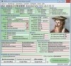
Marine Software Bundle Vista Edition
Draft Survey and Lashing calculations Marine Software Bundle is a user-friendly Draught Survey calculation program for Ships' Officers and Marine Surveyors. It is easily operated using either Keyboard or Mouse. Marine Software Bundle complies with the

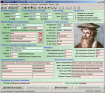
MarinersOffice
Maritime Software - Draft Survey, Lashing and Route calculations for Merchant Navy. User-friendly Draft Survey, Lashing Calculations and Route Planning software for Ships' Officers and Marine Surveyors. Mariners Office is easily operated using either

MarineSoftware VE
Draft Survey and Lashing calculations Marine Software Bundle is a user-friendly Draught Survey calculation program for Ships' Officers and Marine Surveyors. It is easily operated using either Keyboard or Mouse. Marine Software Bundle complies with the
Maritime Software Suite v.9.4
Maritime Software Suite is a user-friendly Draft Survey, Lashing Calculations and Route Planning program for Ships' Officers and Marine Surveyors. Maritime Software Suite is easily operated using either Keyboard or Mouse.
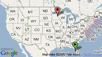
GreatCirc v.2.1
GreatCirc is a software for calculating Great Circle distances on the earth's surface, and plotting points and outstanding circle paths on a world map.Basic Features 1. Great Circle Distance calculation: find the shortest distance and direction

GeoDLL Deutsch v.14.60
GeoDLL supports the development of geodetic software on various platforms by providing geodetic functions. GeoDLL contains precise calculations on the themes 2D and 3D coordinate transformation, geodetic datum shift and reference system and more.
GeoDLL English v.14.60
GeoDLL supports the development of geodetic software on various platforms by providing geodetic functions. GeoDLL contains precise calculations on the themes 2D and 3D coordinate transformation, geodetic datum shift and reference system and more.